
Understand Risk
Wildfire risk is based on several factors: likelihood, intensity, exposure, and susceptibility. Understanding which factors affect your community can help you prioritize risk reduction activities.
A community’s wildfire risk is the combination of likelihood and intensity (together called “hazard”) and exposure and susceptibility (together called “vulnerability”).


Wildfire Likelihood
About Wildfire Likelihood
Wildfire likelihood is the annual probability of wildfire burning in a specific location. At the community level, wildfire likelihood is averaged where housing units occur.
Wildfire likelihood is based on fire behavior modeling across thousands of simulations of possible fire seasons. In each simulation, factors contributing to the probability of a fire occurring, including weather, topography, and ignitions are varied based on patterns derived from observations in recent decades. Wildfire likelihood is not predictive and does not reflect any currently forecasted weather or fire danger conditions.
Wildfire likelihood is simply a probability that any specific location (pixel) may experience wildfire in any given year. It does not say anything about the intensity of fire if it occurs.

Explore Wildfire Likelihood
Explore your community’s wildfire likelihood in the interactive data viewer. Wildfire likelihood is a component of the tabs called “Risk to Homes” and “Wildfire Likelihood.”
Reduce Wildfire Likelihood
Wildfire likelihood can be difficult to modify, but wildfire prevention, response, and fuel treatments are steps communities can take to reduce likelihood.

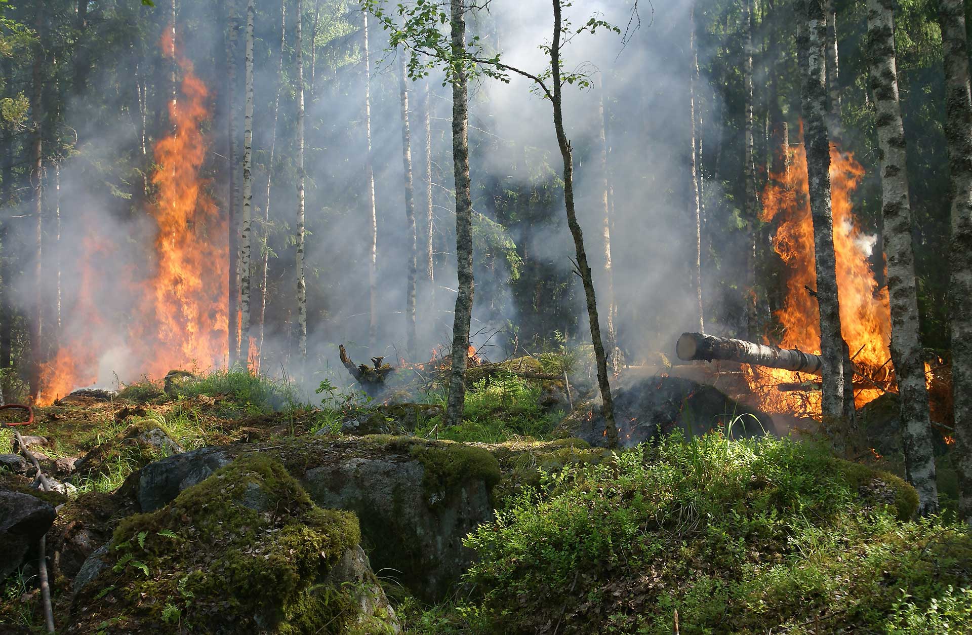
Wildfire Intensity
About Wildfire Intensity
Wildfire intensity is a measure of the energy expected from a wildfire.
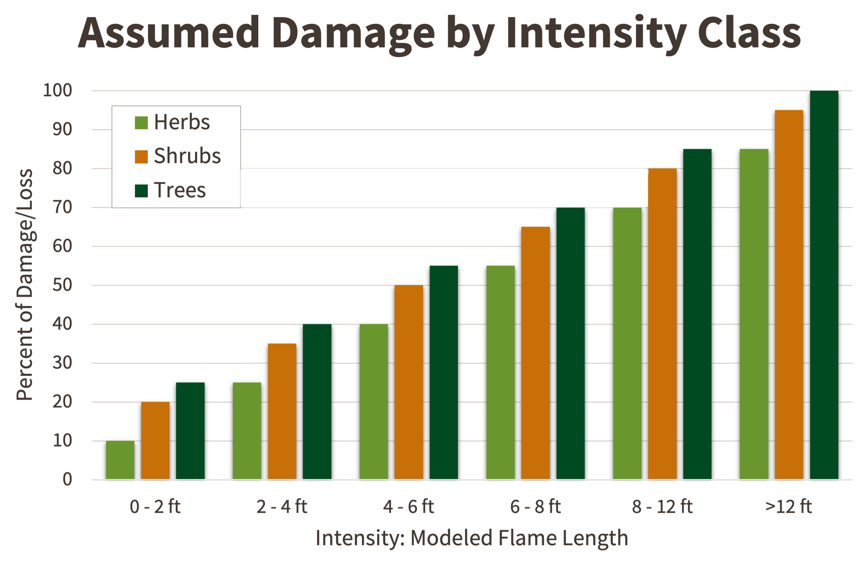
Intensity is largely a condition of the physical landscape (topography) and vegetative fuel available to burn. For example, a crown fire on a forested hillside can produce a greater wildfire intensity than grasses on flat ground. While wildfire intensity is technically measured in units of heat transfer per length of fire perimeter, it is more easily observed and expressed in terms of flame length. Wildfire Risk to Communities uses wildfire intensities calculated in fire behavior modeling simulations.
Explore Wildfire Intensity
Explore your community’s wildfire intensity in the interactive data viewer. Wildfire intensity is a component of the tabs called “Risk to Homes.”
Reduce Wildfire Intensity
Wildfire intensity can be reduced by modifying the home ignition zone, land use planning, wildfire response, and fuel treatments.

Exposure
About Exposure
Exposure is the spatial coincidence of wildfire likelihood and intensity with communities.
Any community that is located where wildfire likelihood is greater than zero (in other words, where there is a chance wildfire could occur) is exposed to wildfire. For example, a home in a flammable forest is exposed to wildfire.
Communities can be directly exposed to wildfire from adjacent wildland vegetation, or indirectly exposed to wildfire from embers and home-to-home ignition.
Explore Exposure
Explore your community’s exposure in the interactive data viewer. Wildfire intensity is a component of the tabs called “Exposure Types.”
Reduce Wildfire Exposure
Communities can reduce their exposure to wildfire with actions such as modifying the home ignition zone, home hardening, land use planning tools, and wildfire preparedness.
Susceptibility
About Susceptibility
Susceptibility is the propensity of a home or community to be damaged if a wildfire occurs.
Wildfire Risk to Communities uses a generalized concept of susceptibility for all homes. In other words, Wildfire Risk to Communities assumes all homes that encounter wildfire will be damaged, and the degree of damage is directly related to wildfire intensity.
Wildfire Risk to Communities does not account for homes that may have been mitigated, and does not measure other important resources that may be damaged by a wildfire (such as infrastructure, watersheds, or forest health).
In reality, an individual home’s ability to survive wildfire is driven primarily by local conditions (known as the “Home Ignition Zone”), including the construction materials and the vegetation in the immediate area. The only way to truly assess home susceptibility is through individual home assessments, which are well beyond the scope of Wildfire Risk to Communities.
Explore Susceptibility
Explore your community’s susceptibility in the interactive data viewer. Susceptibility is a component of the tabs called “Risk to Homes” and “Vulnerable Populations.”
Reduce Susceptibility
Communities have many opportunities to reduce their susceptibility. Actions that affect susceptibility include home hardening, modifying the home ignition zone, applying land use planning tools, wildfire preparedness, community health strategies, and planning for post-fire recovery.

Read more about wildfire risk:
- Ager AA, Day MA, Palaiologou P, Houtman RM, Ringo C, Evers CR. (2019). Cross-boundary wildfire and community exposure: A framework and application in the western U.S. USDA Forest Service, Rocky Mountain Research Station, General Technical Report RMRS-GTR-392.
- Ager AA, Kline JD, Fisher AP. (2015). Coupling the biophysical and social dimensions of wildfire risk to improve wildfire mitigation planning. Risk Analysis 35(8), 1393-1406.
- Brenkert-Smith H, Dickinson K L, Champ P A, & Flores N. (2013). Social amplification of wildfire risk: The role of social interactions and information sources. Risk Analysis, 33(5), 800-817.
- Calkin DE, Cohen JD, Finney MA, Thompson MP. (2014). How risk management can prevent future wildfire disasters in the wildland-urban interface. PNAS 111(2), 746-751.
- Finney MA. (2005). The challenge of quantitative risk analysis for wildland fire. Forest Ecology and Management 211, 97-108.
- McCaffrey S, McGee TK, Coughlan M. (2020). Understanding wildfire mitigation and preparedness in the context of extreme wildfires and disasters: Social science contributions to understanding human response to wildfire. In: Tedim F, Leone V, McGee TK, eds. Extreme Wildfire Events and Disasters. Elsevier. 155-174.
- Menakis JP, Cohen JD, & Bradshaw L. (2003). Mapping wildland fire risk to flammable structures for the conterminous United States. In Galley KEM, Klinger RC, & Sugihara NG (Eds.), Proceedings of Fire Conference 2000: The First National Congress on Fire Ecology, Prevention, and Management. Misc. Pub. No. 13 (pp. 41-49). Tallahassee, FL: Tall Timbers Research Station.
- Radeloff VC, Mockrin MH, Helmers D, Carlson A, Hawbaker TJ, Martinuzzi S, Schug F, Alexandre PM, Kramer HA & Pidgeon A. (2023). Rising wildfire risk to houses in the United States, especially in grasslands and shrublands. Science 382(6671): 702-707.
- Scott JH, Thompson MP, Calkin DE. (2013). A wildfire risk assessment framework for land and resource management. USDA Forest Service, Rocky Mountain Research Station, General Technical Report RMRS-GTR-315.


Learn how these actions align with federal policies and initiatives.