Land Use Planning
Direct how communities develop with plans and regulations in wildfire-prone areas.
About Land Use Planning
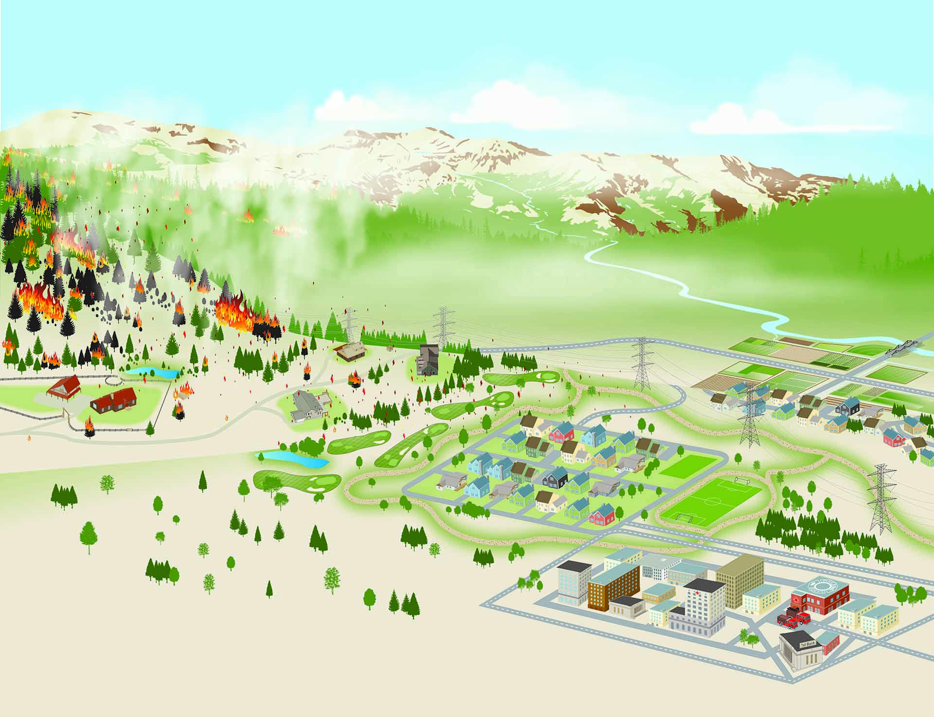
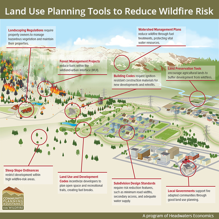
Land use planning can reduce wildfire risk by helping communities grow and develop with wildfire in mind. Land use planning tools such as zoning, plans, regulations, and building codes can influence the design, layout, and placement of homes built in wildfire-prone areas.
Land use planning measures are diverse and can be customized to fit the needs of the neighborhood, community, or county. For example, land use planning regulations can require defensible space in the home ignition zone, adequate water supply, road widths and access, and home hardening materials for homes built in high wildfire hazard areas. Land use planning tools can also restrict development in areas of highest hazard.

Explore your community’s risk.
Community Tools
Fire Adapted Communities Learning Network
The Fire Adapted Communities Learning Network connects and supports people and communities who are striving to live more safely with wildfire. The purpose of FAC Net is to exchange information, collaborate to enhance the practice of fire adaptation, and work together and at multiple scales to help communities live safely with fire. This includes embracing resiliency concepts and taking action before, during and after wildfires. They offer a Fire Adapted Communities Self-Assessment Tool (FAC SAT) to help communities assess their level of fire adaptation and track their capacity to live safely with fire over time
Community Planning Assistance for Wildfire
Community Planning Assistance for Wildfire (CPAW) works with communities to reduce wildfire risk through improved land use planning. CPAW’s team of professional planners, foresters, economists, and risk modelers help communities integrate wildfire mitigation into the development planning process. CPAW services are provided at no cost to the community, and include land use planning recommendations, hazard assessments, custom research, and training.

Hispanic Access Foundation Wildfire Toolkit
Latino communities are more vulnerable to experiencing the adverse effects of wildfires. The Hispanic Access Foundation Wildfire Toolkit provides resources about regulations and policies, public and mental health, and response and recovery issues to help communities address Latino considerations related to wildfire.

American Planning Association: Planning the Wildland-Urban Interface
This free guide from the American Planning Association offers planners an in-depth introduction to the WUI and wildfire basics, covering challenges, trends, and historical context along with the latest wildfire science. It then moves to solutions, providing a holistic planning framework and practical guidance on how to address WUI and wildfire challenges in plans, policies, and regulations.

Firetopia Land Use Planning Toolkit
The Firetopia Land Use Planning Toolkit includes sample code language, community case studies, and best practices for creating wildfire-resilient land use planning practices. Firetopia addresses community plans, land development regulations, building and fire codes, and funding. It was created by the Community Planning Assistance for Wildfire (CPAW) program.

Equitable Development and Environmental Justice
Developed by the Environmental Protection Agency, this free toolkit provides resources for planners in meeting the needs of underserved communities through policies and programs.

Fire Prevention and Safety (FP&S) Grant Program
FEMA’s Fire Prevention and Safety (FP&S) grant program provides funding for fire prevention programs and supports firefighter health and safety research and development. Wildland urban interface projects such as community risk assessments, adoption or reinstatement of WUI fire codes, and WUI education/awareness projects are funded.

Building Resilient Infrastructure and Communities (BRIC)
FEMA’s Building Resilient Infrastructure and Communities (BRIC) program provides support to states, local communities, Tribes, the District of Columbia, and territories as they undertake hazard mitigation projects, reducing the risks they face from disasters and natural hazards.
Community Wildfire Defense Grants (CWDG)
The Community Wildfire Defense Grant (CWDG) program provides grants to communities at risk from wildfire to develop or revise their community wildfire protection plans and carry out mitigation projects described within those plans. It is administered by the USDA Forest Service.
Drinking Water System Resilience Program
The Environmental Protection Agency’s (EPA’s) Drinking Water System Infrastructure Resilience and Sustainability Program funds projects in underserved communities and small communities (fewer than 10,000 people). Projects must increase resilience of drinking water systems to natural hazards, including wildfire. Planning and infrastructure improvements are funded.

Suburban Wildfire Adaptation Roadmaps
The Insurance Institute for Business & Home Safety developed the Suburban Wildfire Adaptation Roadmaps to provide decision trees for homes and businesses to reduce vulnerability to wildfire. When put into action by homeowners, business owners, and ultimately whole communities, the risk curve can be bent downward and limit the catastrophic reach of wildfires.
Research & Science
- Alexandre PM, Stewart SI, Mockrin MH, Keuler NS, Syphard AD, Bar-Massada A, Clayton MK, & Radeloff VC. (2015). The relative impacts of vegetation, topography and spatial arrangement on building loss to wildfires in case studies of California and Colorado. Landscape Ecology, 31(2), 415– 430.
- Barrett K & Rasker R. (2016). Land Use Planning to Reduce Wildfire Risk: Lessons from Five Western Cities.Bozeman, MT: Headwaters Economics.
- Barrett K. (2019). Reducing Wildfire Risk in the Wildland-Urban Interface: Policy, Trends, and Solutions.Idaho Law Review, 55(3).
- Cohen J, Johnson N, & Walther L. (2001). Saving Homes from Wildfires: Regulating the Home Ignition Zone. Zoning News. Chicago, IL: American Planning Association.
- Mockrin MH, Fishler HK, & Stewart SI. (2020). After the fire: Perceptions of land use planning to reduce wildfire risk in eight communities across the United States. International Journal of Disaster Risk Reduction, 45, 101444.
- Moritz M & Butsic V. (2020). Building to coexist with fire: Community risk reduction measures for new development in California (University of California Agriculture and Natural Resources Publication No. 8680).
- Mowery M, Read A, Johnston K, & Wafaie T. (2019). Planning the Wildland-Urban Interface. PAS Report 594. Chicago, IL: American Planning Association.
- Renner C, Reams M, & Haines T. (2006). Mitigating Wildfire Risk in the Wildland Urban Interface: The Role of Regulations. In Aguirre-Bravo C, Pellicane PJ, Burns DP, & Draggan S. (Eds.), Monitoring Science and Technology Symposium: Unifying Knowledge for Sustainability in the Western Hemisphere. Proceedings RMRS-P-42CD (pp. 715-722). Fort Collins, CO: USDA Forest Service, Rocky Mountain Research Station.
Learn how these actions align with federal policies and initiatives.


